
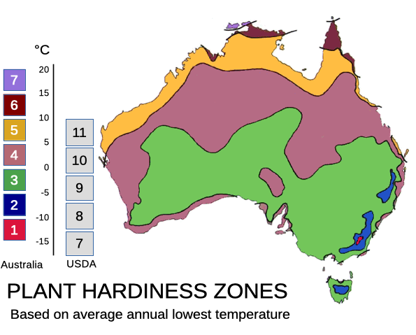
Plant hardiness maps allow producers to label their plants as being suitable for particular areas, and, in theory at least, this results in happy customers who can confidently buy plants that will survive in their locality.
Traffic Light Guide for Frost Tolerance of Cacti and Succulents growing in the Canberra Region
This guide to frost-hardiness of cacti and succulents was prepared by members of CSSACT specifically for growers in Canberra and the surrounding region. The guide was informed by the Tuscon Cactus and Succulent Society ABC123 Guide. The traffic light style was developed by Karl Rumba, and notes were mainly developed by Trevor Rodgers of the Society.
Cactus and Succulents for the ACT
Here are some of the cactus and succulent plants which have been grown successfully outdoors in the ACT. How well they grow will still depend on such things as soil mix, aspect, watering and pest control.
These are not comprehensive lists, but will give you an idea of some of plants that can be grown in the ACT region. The Canberra region experiences a number of frosts, from April to September. Frost is a significant threat to many cacti and succulents - this list has taken that into consideration frost tolerance.
Alternate names as provided in recent publications are given in brackets.
Cacti Suitable For ACT Gardens
|
Astrophytum species eg A. ornatum |
Coryphantha species |
Echinocereus species |
|
Echinopsis species |
Escorbaria species | Ferocactus species
eg F. townsendianus |
|
Gymnocalcium species (most of this genus) |
Leutchtenbergia principis |
|
|
Mammillaria species in moderate frosts eg |
Mammillaria candida |
Mammillaria parkinsonii |
|
Oreocereus species eg O. celsianus |
Parodia species
eg P. magnificus |
Pediocactus species |
|
Rebutia species |
Stenocactus species |
Tephrocactus species |
25 Succulents Suitable For ACT Gardens
Agave parviflora |
Agave schidigera |
Agave victoriae-reginae |
|
Agave utahensis |
Aloe aristata |
Aloe brevifolia |
|
Aloe distans |
Cephalophyllum pulchrum |
Echeveria elegans |
|
Echeveria shaviana |
Euphorbia caput medusae |
Euphorbia cerieformis |
|
Euphorbia obesa |
Euphorbia pentagona |
Euphorbia resinifera |
|
Faucaria |
Gasteria liliputana |
Graptopetalum |
|
Haworthia |
Pachyphytum compactum |
Sedum |
|
Sempervivum |
Stomatium |
|
Growing Cacti and Succulents in the Canberra Region
Excerpt of article from Newsletter: November 2012, Volume 34, Number 4
Firstly, let me define what I mean by the Canberra region and why our growing conditions offer particular challenges.
The highland areas of the South East NSW incorporate the Southern Tablelands and mountain areas of the ACT and NSW borders. Included in this area are the main centres of Goulburn, Canberra, Queanbeyan and Cooma.
Because the whole region at over 600 metres above sea level, it experiences some of the highest average hours of sunshine in Australia; consequently the UV level is very high.
The region experiences cold, frosty winters and warm to occasionally hot summers. Rainfall occurs throughout the year with an average around 600mm; a little less over the winter months and somewhat more in spring. Summer rain is often associated with thunderstorms.
Winters offer a particular challenge as temperatures can drop as low as -8C, and it is not unusual to have a series of nights with minus 6C minimums. When these low temperatures occur over several days all plants, not just cacti and succulents are likely to suffer some permanent damage.
The opposite challenge occurs when we experience particularly hot weather with temperatures reaching into the high 30’s and even low 40’s as these days are usually associated with north westerly winds that will scorch plants.
As a general rule cacti tend to cope better with these extremes than succulents. Since the inception of CSSACT in the late 1960’s members have been experimenting with plants species to determine their suitability for growing in this region. The most significant challenge however, is getting your plants through the cold winter months, whether they are under cover or planted out in the garden.
There are 4 aspects to growing success with cacti and succulents in our region -
- The soil mix,
- The selection of plants,
- The location and
- Watering
(The article continues, addressing the four aspects)
How to Root a Succulent Leaf
(Published in the December 2016 newsletter, volume 38 number 5, with permission from World of Succulents)
Succulents are plants that survive long periods of drought by storing water in leaves, stems or roots. Their stems or roots become thick and fleshy when retaining water. Most succulents prefer dry conditions and grow well in containers. Succulents come in a variety of shapes and colors and propagate easily through leaf cuttings. Container-grown succulents require little maintenance while adding color and texture to a deck, porch or room.
- Collect a succulent leaf cutting in the spring or summer when the plant is actively growing. Choose a healthy plant with no signs of damage or disease from which to take the cutting. Select a healthy leaf without blemish. Remove the leaf from the plant, breaking it or cutting it off with a knife at the point where the leaf connects with the stem. Place the leaf on a piece of paper, and set it in a dark, dry, well-ventilated room for one to two days to allow it to dry and form callus tissue over the cut end.
- Choose a container for the leaf cutting. Select a container that has drainage holes in the bottom and is at least 10 cm deep. Consider containers in colors and shapes that accentuate the chosen variety of succulent and the space it will be growing in.
- Mix one part potting soil, two parts vermiculite and two parts perlite together to create a well-draining growing medium. Fill the container with the mixture, tamping it down firmly. Leave a 2.5 cm space between the soil surface and the top of the container. Water the soil in the container with a watering can two to three times to ensure it is evenly moist.
- Dip the cut end of the leaf in rooting hormone. Push the cut end of the leaf down into the soil in the container until one-third to one-half of the leaf is buried. Tamp the soil down around the bottom of the leaf to stabilize it.
- Place the container in an area with a constant temperature of 18 degrees Celsius or warmer. Choose an area with bright indirect sunlight. Water the leaf cutting only when the top one-fourth layer of soil becomes dry. Mist the cutting once per day with a spray bottle to increase the humidity level. Watch for new growth to appear four to six weeks after planting, signaling that the plant has established roots.
For more information go to worldofsucculents.com or on Facebook @worldofsucculents.
Tools
(proposed article)
How do you know when to re-pot?
Excerpt of Newsletter: October 2012, Volume 34, Number 2
Here are 11 reasons our members re-pot their plants:
- Plants are so large they are falling out of the pot and the pot looks like it’s expanding.
- Pot breaking or cracking. Pot could be too old or plant too large.
- Soil level has gone down or is shrinking in from the sides; the plant would have used much of the nutrients in the soil.
- Squeeze the pot – does it resist or easy to squeeze? Is there enough soil in the pot?
- Roots growing out of the bottom.
- Rootball is like a “rock”.
- Plant stops growing.
- Plant looks half dead; when re-potting you can check the roots.
- When water goes straight through the mix.
- There are lots of weeds in the pot.
- Don’t like the colour of the pot.
- When to re-pot? After the plant stops flowering.
Thanks everyone for suggestions which were both humorous and serious. I now know that all my plants need re-potting.
Special thanks to the late Phil Robson for launching the Big Question as a way for all of us to share our experience and ideas.
Some background to taxonomy of cacti
Over the last century there have been a number of revisions of the taxonomy (the naming and classifying) of Cacti.
The most recent revision of cactus taxonomy was published in the New Cactus Lexicon by David Hunt in 2006. http://www.newcactuslexicon.org
Why you may like to know the official name
it is useful to know what is the official name of a cactus or succulent when you are looking at plant and seed lists, or for information on their requirements.
It is especially handy to know whether the name you are using is treated as a synonym and if so, what is the official name.
ITIS webpage - A handy web based reference for plant taxonomy
One of the easiest ways to check for the official name of a cactus is to use the Integrated Taxonomic Information System (ITIS for short). http://www.itis.gov/
This first page is the launching point for any search you do, so putting cactacea in the scientific name box will give you a summary reporting page of the accepted genus names for cacti.
Alternatively you can enter the name of a plant and the result will tell you if the name is accepted or is a synonym, and what the correct name is.
Happy name hunting!
Until we get our own text, please refer to World of Succulents.
https://worldofsucculents.com/succulent-plants-problems-sunburn/
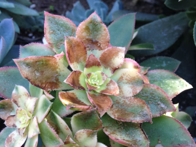

Above is a photo of what I believe is a Cleistocactus growing in my garden. It is planted under the eaves of the house along the north facing side of the house, driveway side. For the last few years it has had some minor dieback on a branch or two but this year (2016) this has been quite significant. I have cut back all the dead branches well beyond where the damage is and there does not seem to be any visible disease or other problem. Can anyone identify or suggest a cause for this problem?